Your benefits at a glance:
- Easy data collection in the office and on the move
- Extensive map and plan material
- Templates for recurring objects
- Lists of all objects for preparing the event
- Task-specific icons for structuring
- Print preparation
- Import and export of geodata
An event in public space requires permits. The temporary conversion of public space, the restrictions on use by the general public and any hazards that may arise must be described, evaluated and weighed against other assets.
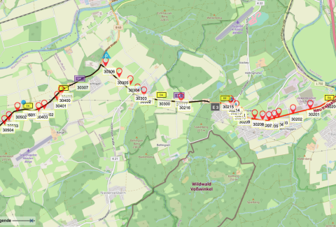
placeit supports every approval process. Structures, routes and evacuation plans can be drawn on the basis of official maps. Authorities receive printouts that are always up to date. And during meetings, the tablet can be used to immediately draw in changes.
 With placeit, you can start planning your event at a very early stage. You record all relevant data such as closed roads, routes, event grounds, entry and escape routes in a web-based database. And you don't use the usual internet maps, which are far too inaccurate for this, but official maps and even special maps provided by the police, fire department or other emergency services.
Standard electronic maps are unsuitable for reliable planning. They do not show important details or show them inaccurately. For professional planning, you need official maps, aerial photographs and, if necessary, even your own plans and images that can be edited. This is the only way everyone knows exactly what is going on.

You can also work outside in the field. You no longer make sketches by hand or notes in a notebook, which you later transfer to your drawing program, but work immediately and precisely. This is efficient and saves time. As one of our customers says: about 30% time saving.